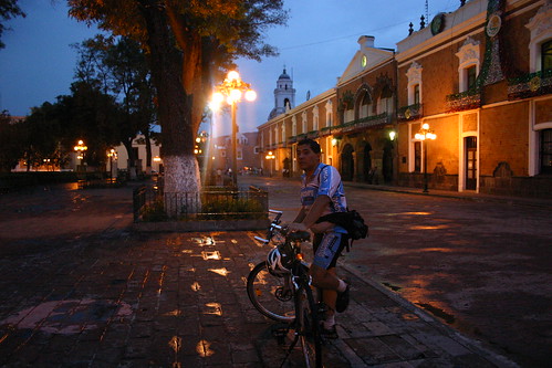
Iguala (Guerrero), 30.10.05
GPS Track Video
Photoset Show
GPS Track: GPX (MapSource, et al.) or KMZ (Google Earth)
GPS Cycling Data:


Distance: 183 Km. Ascent: 1645 m. Time: 7:22 hr, Avg Speed: 25.1 Km/hr, Max Speed: 57.4 Km/hr
Travel Report:
Esta rodada fue realizada el pasado domingo 30.10.05, sin embargo, no había sido correctamente documentada. Por tanto la documentamos ahora aprovechando la nueva versión (Beta 4) de Google Earth para hacer que el video luzca súper :-)
Para variar, iniciamos muy tarde, creo que por ahi de las 13:00 hrs (esa mala costumbre de levantarse tarde los domingos). Iniciamos en Gral Anaya, al sur de la Ciudad de México, sobre Tlalpan. Tomamos todo Tlalpan hasta el Monumento al Caminero y luego nos seguimos por la autopista a Cuernavaca. Sin mayores problemas llegamos a La Cima (Km 46) y de ahí derecho hasta Cuernavaca, previa parada en el Mirador de la Pera para tomar unas fotos de la hermosa vista.
Continuamos hasta Xochitepec donde hicimos un corto descanso, pudiendo constatar que el calor venía en serio. Es en Xochitepec (Cerro de las Flores) donde hay muchos puestos de flores a la orilla de la carretera. Seguimos adelante y llegamos a la caseta de Alpuyeca, donde pudimos comprobar que hacía un soberano calor (la ventaja de los descensos es que no sientes el calor, pero en cuanto te detienes parece que entras a un horno).
Tomamos la desviación hacia Puente de Ixtla, siguiéndonos derecho hasta Amacuzac, pues el tiempo apremia. En Amacuzac comí algo en una gasolinería y nos planteamos la disyuntiva sobre si continuamos o no con la ruta hasta Iguala, pues era ya muy tarde (aprox las 17:00 hrs). Además, Amacuzac representa el punto de no retorno, pues más adelante sólo queda la montaña, y ya no hay poblados grandes sino hasta Iguala.
Pues haciendo acopio de valor (o de necedad), nos lanzamos a la aventura, y decidimos cruzar la montaña, a pesar de lo tarde que era. Justo cuando el sol se metió, cruzamos la frontera con el estado de Guerrero. Por fin, atrás de nosotros quedaba Morelos. Sin embargo, aún nos falta continuar con el ascenso de la montaña.
Es ya de noche cuando llegamos a un pueblo llamado Zacapalco. Comemos algo allí y continuamos. La ventaja de que ya cayó la noche es que ya no hace calor :-) Pasamos la desviación a Buenavista. Llegamos por fin a la desviación a Tuxpan, donde termina el ascenso. Sin embargo, ahora comienza lo mas peligroso, 500 metros de descenso (altitud): de noche, solo y sin luces ! Misión suicida ! Justo como la que la otra vez hice al bajar de regreso de Llano Grande (en la autopista a Puebla) hacia el DF, también de noche, solo y sin luces (y con un frío de temperaturas sub-cero), pero esa será una historia a relatar en otra ocasión :-)
Y bueno, me dije: tomo o no el camión para el descenso y me respondí: no, si podemos :-) Comencé a bajar con cuidado, guiándome tan sólo con los faros de los carros que venían de frente, aunque también me deslumbraban (pues la carretera era de doble sentido, sin malla enmedio). De pronto que me rebasa un camión carguero de esos viejitos, que apenas y se les veían los cuartos. Y que me le pego ! Gracias a ese camioncito de carga pude bajar ya sin problemas, pues el camión me tapaba las luces de los autos de enfrente, además de que por sus cuartos ya me veían los autos de atrás. De esta manera pude llegar sano y salvo a la caseta de Iguala que está al terminar el descenso :-)
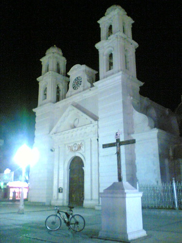
Entré pues a la ciudad de Iguala por ahi de las 21 hrs, pasando al centro a tomar fotos. De hecho inclusive me dió tiempo de presenciar una noche de fiesta en el Kiosko del centro, así como la exposición de ofrendas de muertos :-) Cené algo y me dirigí a la terminal del Estrella de Oro para tomar el autobús de regreso a México.
Allí continuó la diversión, pues ya no había camiones a México (el último creo que sale a las 19:00 hrs) ... Tuve que esperarme en la terminal (muy cómoda por cierto, y donde nos dejaron dormitar tranquilos) a que llegara un autobús de paso que venía del puerto de Acapulco (por ahi de las 03:00 hr), pero que siendo directo, me trajo sin escalas al DF, sin tener que hacer transbordo en Cuernavaca. Lo bueno es que traía lugares :-)
Gracias por leer. Hasta el próximo viaje.
GPS Track: GPX (MapSource, et al.) or KMZ (Google Earth)
GPS Cycling Data:


Distance: 183 Km. Ascent: 1645 m. Time: 7:22 hr, Avg Speed: 25.1 Km/hr, Max Speed: 57.4 Km/hr
Travel Report:
Esta rodada fue realizada el pasado domingo 30.10.05, sin embargo, no había sido correctamente documentada. Por tanto la documentamos ahora aprovechando la nueva versión (Beta 4) de Google Earth para hacer que el video luzca súper :-)
Para variar, iniciamos muy tarde, creo que por ahi de las 13:00 hrs (esa mala costumbre de levantarse tarde los domingos). Iniciamos en Gral Anaya, al sur de la Ciudad de México, sobre Tlalpan. Tomamos todo Tlalpan hasta el Monumento al Caminero y luego nos seguimos por la autopista a Cuernavaca. Sin mayores problemas llegamos a La Cima (Km 46) y de ahí derecho hasta Cuernavaca, previa parada en el Mirador de la Pera para tomar unas fotos de la hermosa vista.
Continuamos hasta Xochitepec donde hicimos un corto descanso, pudiendo constatar que el calor venía en serio. Es en Xochitepec (Cerro de las Flores) donde hay muchos puestos de flores a la orilla de la carretera. Seguimos adelante y llegamos a la caseta de Alpuyeca, donde pudimos comprobar que hacía un soberano calor (la ventaja de los descensos es que no sientes el calor, pero en cuanto te detienes parece que entras a un horno).
Tomamos la desviación hacia Puente de Ixtla, siguiéndonos derecho hasta Amacuzac, pues el tiempo apremia. En Amacuzac comí algo en una gasolinería y nos planteamos la disyuntiva sobre si continuamos o no con la ruta hasta Iguala, pues era ya muy tarde (aprox las 17:00 hrs). Además, Amacuzac representa el punto de no retorno, pues más adelante sólo queda la montaña, y ya no hay poblados grandes sino hasta Iguala.
Pues haciendo acopio de valor (o de necedad), nos lanzamos a la aventura, y decidimos cruzar la montaña, a pesar de lo tarde que era. Justo cuando el sol se metió, cruzamos la frontera con el estado de Guerrero. Por fin, atrás de nosotros quedaba Morelos. Sin embargo, aún nos falta continuar con el ascenso de la montaña.
Es ya de noche cuando llegamos a un pueblo llamado Zacapalco. Comemos algo allí y continuamos. La ventaja de que ya cayó la noche es que ya no hace calor :-) Pasamos la desviación a Buenavista. Llegamos por fin a la desviación a Tuxpan, donde termina el ascenso. Sin embargo, ahora comienza lo mas peligroso, 500 metros de descenso (altitud): de noche, solo y sin luces ! Misión suicida ! Justo como la que la otra vez hice al bajar de regreso de Llano Grande (en la autopista a Puebla) hacia el DF, también de noche, solo y sin luces (y con un frío de temperaturas sub-cero), pero esa será una historia a relatar en otra ocasión :-)
Y bueno, me dije: tomo o no el camión para el descenso y me respondí: no, si podemos :-) Comencé a bajar con cuidado, guiándome tan sólo con los faros de los carros que venían de frente, aunque también me deslumbraban (pues la carretera era de doble sentido, sin malla enmedio). De pronto que me rebasa un camión carguero de esos viejitos, que apenas y se les veían los cuartos. Y que me le pego ! Gracias a ese camioncito de carga pude bajar ya sin problemas, pues el camión me tapaba las luces de los autos de enfrente, además de que por sus cuartos ya me veían los autos de atrás. De esta manera pude llegar sano y salvo a la caseta de Iguala que está al terminar el descenso :-)
Entré pues a la ciudad de Iguala por ahi de las 21 hrs, pasando al centro a tomar fotos. De hecho inclusive me dió tiempo de presenciar una noche de fiesta en el Kiosko del centro, así como la exposición de ofrendas de muertos :-) Cené algo y me dirigí a la terminal del Estrella de Oro para tomar el autobús de regreso a México.
Allí continuó la diversión, pues ya no había camiones a México (el último creo que sale a las 19:00 hrs) ... Tuve que esperarme en la terminal (muy cómoda por cierto, y donde nos dejaron dormitar tranquilos) a que llegara un autobús de paso que venía del puerto de Acapulco (por ahi de las 03:00 hr), pero que siendo directo, me trajo sin escalas al DF, sin tener que hacer transbordo en Cuernavaca. Lo bueno es que traía lugares :-)
Gracias por leer. Hasta el próximo viaje.
