November 27, 2006

Zacatepec (Morelos), 26.11.06


Map Navigation: This dynamic Trackmap shows the GPS track (red line) and some geo-referenced photos (red dots) of the cycling tour. Wheel up and wheel down your mouse to zoom in or zoom out the map. Click on any point in the map to center it on that point. Or just drag the map with your mouse. To see the photos, hoover the mouse over the red dots. Click on the photo to go to the picture page.


Photoset Map

Photoset Show

GPS Track: GPX (MapSource, et al), or KMZ (Google Earth)

GPS Cycling Data:


Distance: 135 Km, Total Ascent: 1000 m


Travel Report:

It is a pity that I can arrive early only to others invitation to ride. This travel to Zacatepec (in the southern state of Morelos) started at 13:00, because as usual: I had to sort some things on Sunday morning (things that must get sorted the day before). This route to Cuernavaca is becoming our most beloved route. It usually offers good weather, provides a good elevation (if rided both ways) and its free highway has a lot of towns along the road in case of need. It even offers some 17 km as "jogging" before the ascent starts. The only drawback I notice is that the summit top is a little flat, compared for example against Llano Grande, on the road to Puebla, so you can't know where the hell is the real summit. That is why I have decided to mark it on Km 44.

First thing in this route is to take Tlalpan, a big big avenue that cuts the city in two parts, north-south direction. Its big advantage is that it has no traffic signals, so you can ride on this avenue at 40 Km/hr with no problem, the only limitation are your legs :-). You have to save them for the oncoming ascent to La Cima. Again, this summit has an altitude of only 3020 m, 200 m less than Llano Grande, but well, you can not always ride to Puebla :-)

Tlalpan was full of traffic, owed to the late hour and to a soccer match that was being played in a big stadium along this street. Police forces were present in every corner ! I guess in order to prevent vandalism. Once we took the free highway to Cuernavaca, the traffic diminished, and now our only concern was the sun. We had lots of it. But i do not make any complaints. After last Sunday's ride to Puebla under heavy rain for the most part of the day, a ride under an unobstructed sun is always welcomed. This time we decided not to stop is the Mirador, a sightseeing points at 2700 m, because the traffic negotiation in that point gets always a little complicated, and we have been there over 4 times (in past rides), so we decided it was time to forget that custom.

So we headed direct to our first stop (to take a picture): summit La Cima. We passed Parres (last town in the city), leaving behind the DF. But just before we reached La Cima, there was an accident on the highway, involving a motorbike, whose driver had crashed against the contention wall in a curve. The motorbike was on the floor (with big apparent damages), but its driver did not appear near. Other motorbikers were looking for him in the surrounding area. It was really a sad view. At that time, I did remember the motto: "Speed kills". In fact, after La Cima, there was a second accident, this time involving a car, which rested on its roof ! 2 accidents in a couple of kilometers. The ambulances were arriving at both sites. After taking our mandatory picture at the summit La Cima, we started our descent to Cuernavaca.

I can not say a lot of the descent, as my five senses were fixated in the road conditions and traffic (in both lanes). When I arrived at the Zapata (alt: 1800 m) I couldn't stop there to take a picture, because there was a lot of traffic, so I continued to La Paloma (the Dove), in order to gain access to the Libramiento (a big big turn around the city of Cuernavaca, in order to avoid its traffic jam). Once we took a picture on the Libramiento, we started giving the city a turn, just to take the free highway to Acapulco, once we encounter it at the other side of Cuernavaca.

We rided to Temixco and to Acatlipa, two towns along the road to Acapulco. In Acatlipa we took a road that enabled us to cross the autopista (paid highway) to Acapulco, since we were heading to Zacatepec (which was on the other side of this highway). The route that we have decided to take was a new one, shorter that the conventional one, but now i reckon it was more hilly. We headed to Tepetzingo and Acamilpa. These town appeared like phantom towns as they are far of the bigger cities of the region, but anyway, they were calm and peaceful. On our way we passed the Cementera Cuauhtemoc (a concrete factory). I didn't know it ever existed, and I have been a lot of times in this state (albeit in car). The road was hilly, ups and down, between green fields and running rivers :-) It was an idyllic scene, if it were not for the hurry I was for having started this ride so late.

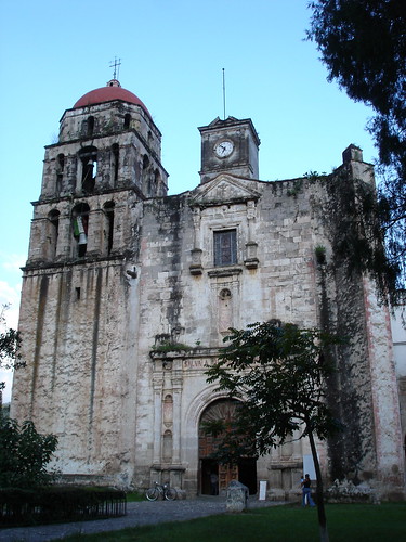
Along the route we reached Pueblo Nuevo, and later Tlaltizapan, where I could pass to salute some friends. After a short stop (because it was now 18:00 and night was looming), I continue the ride, this time to Zacatepec (a city where we could board the bus to get back home). In Tlalquitenango, the darkness took reign and we have to ride the last leg again, under the cover of the night. The good thing was that there was no much traffic, and we could finally arrive at Zacatepec with no surprises. Here we decided to have a look at the Ingenio Emiliano Zapata (sugar cane processing plant, main economy activity of the city) and to the main square, were we could observe its Cathedral, a beautiful high-towered Gothic-styled church, in the middle of this tropical city :-) After taking a couple of shots, we rided to the bus station, where for 73 pesos, we could purchase our home ticket, for the bus that was departing in just three minutes. We arrived at Mexico City 2 hours later (21:30), so I could even took the subway to arrive safe at home :-)

Thank you for reading. Till the next journey.

November 20, 2006

Cholula Archaeological Site + Puebla (Puebla), 19.11.06


Map Navigation: This dynamic Trackmap shows the GPS track (red line) and some geo-referenced photos (red dots) of the cycling tour. Wheel up and wheel down your mouse to zoom in or zoom out the map. Click on any point in the map to center it on that point. Or just drag the map with your mouse. To see the photos, hoover the mouse over the red dots. Click on the photo to go to the picture page.


Photoset Map

Photoset Show

GPS Track: GPX (MapSource, et al), or KMZ (Google Earth)

GPS Cycling Data:


Distance: 140 Km, Ascent: 1173 m, Time: 5:20 hr, Avg. Speed: 23.9 Km/hr, Max. Speed: 66 Km/hr.

Travel Report:


This ride was performed under rain for the most part of the journey. In fact, the rain started when we were leaving Mexico City, and did not not stop until our arrive again to the city ! But anyway, it was a beautiful ride, made to visit and know the stunning underground Great Pyramid of Cholula (Puebla). We have intended to take the free highway to Puebla, but somehow in the middle of the ride, we lose our path and had no alternative but to take the paid highway.

There were no many cyclists on the road, only a pilgrimage to San Miguel (I must thank them for its delicious free tostada that they gave me to eat _over_ the bike). On our ascent to Llano Grande (+3200 m) the body generated heat was able to keep us warm, but at our arrival to the summit, it was damn freezing ! We ate some snacks and started the descent to Texmelucan. This was real cold. Temperature was 5 C + raining ! Even in this weather we managed to reach speeds over 65 km/hr. Arriving to Texmelucan, we left the paid highway, taking now our way to the free highway to Puebla. On the road we passed by the town of Huejotzingo, where we could observe some chinelos dancing on the main square (i think we are in festival mood).

Half an hour later we could finally arrive at Cholula, where the rain made us had a hard time finding a place to leave our bicycles. After eating some exquisite tacos + quesadillas in the local market, we could enter the Archaeological Site and its underground Great Pyramid. You can judge by the photos that this is an experience of its own kind. There are even corridors inside the pyramid that lead to God knows where, as they are closed by the site administration. There are a lot of niche-like pathways that lose itself into the darkness. After taking some shots, we leave this magical place.

We decided to climb up our way to the church of Los Remedios, built on the top of the hill that hides the pyramid (this was a tricky part due to my carbon cycling shoes). The rain made this little ascent a though one. But finally, at the top waited for us a beautiful vista of the Cholula and Puebla valleys. After briefly taking shelter in the church, we started our return to the bikes. But meanwhile, Luis decided to have a look to the surrounding pyramids, so I waited for him where we leave our bikes.

Lastly, only the final leg of our journey (12 km) remained between us and our final destination. At our arrival to the CAPU (central bus station of Puebla) we purchased our return tickets (90 pesos by ADO) and patiently awaited 15 minutes for our home bus :-)

Thank you for reading. Till the next journey.

October 30, 2006

La Marquesa (Mexico), 29.10.06


Map Navigation: This dynamic Trackmap shows the GPS track (red line) and some geo-referenced photos (red dots) of the cycling tour. Wheel up and wheel down your mouse to zoom in or zoom out the map. Click on any point in the map to center it on that point. Or just drag the map with your mouse. To see the photos, hoover the mouse over the red dots. Click on the photo to go to the picture page.


Photoset Map

Photoset Show

GPS Track: GPX (MapSource, et al), or KMZ (Google Earth)

GPS Cycling Data:


Distance: 66 Km, Ascent: 1075 m, Time: 2:57 hr, Avg. Speed: 22.5 Km/hr, Max. Speed: 69.2 Km/hr.

Travel Report:


This cycling touring was almost avoided, because the author had to sort some messy things on Sundays morning. So, it wasn't until past 15:00 hrs when I had time to start this ride. I asked myself: where in hell could i ride at this hour ? And my private daemon answered: "Let's go to La Marquesa, after all, it is only a 2 hours ride, with an acceptable ascent, and we have still sunlight". Well ... i decided to follow his advice and started to ride to Constituyentes, the main avenue that guide us directly to the free Highway to Toluca (the other one is Reforma, but it is slower as it has a lot of turns. Constituyentes, on the other hand, gets you straight to the free highway, albeit with a little more pain).

The weather was excellent at this time, no hard sun, no rain, little wind. This route is an old friend of us, so: no big surprises. Just that as we were ascending, the air became chilly (last night was really cold in town). There was a lot of traffic on the road this time, not surprisingly for the hour. A lot of pick-ups and double trailer trucks :-( I had to manage to ride over the extreme right side white line in order to avoid any chance of being touched by these double carrier trucks. That made me promise to start to ride earlier next Sunday :-).

After 1:45 hr of riding we arrived at the summit: Tres Cruces, with an altitude of 3160 m. I took a couple of photos an started the descent to La Marquesa, 170 m down the other side of the hill. Man, it was cold the descent (but nothing compared with the cold we must deal with at our return to the city). Arrived at La Marquesa at 17:42, took another couple of pictures and start the return, with a moderate ascent of those 170 m in order to arrive again to the summit. There was still sunshine. But night was looming ... and our descent of almost 1,000 m to Mexico City had to start, so we must hurry on.

Occupied in watching carefully the road in the descent, I did not realized at what time there was no more solar light. In fact, there was a car jamming on the highway to the city, so a couple of times i had to ride on the left lane of the highway, in order to overcome to jammed cars of the slow lane. That was adrenaline ! Overcoming jammed two-carriers trucks by the left (high speed) lane in the highway ! But after those precious moments, we have to maintain us focused in order to avoid the potential holes in the middle of the lane, hardly visible at this hour. A police car even protect me in the final stages of the descent (near the Reforma-Constituyentes junction), going back of me at my speed and with its light on ! I had to thank those guys :-)

When I arrived at Constituyentes, there was no more light at all, but there was _another_ big car jam :-) so it was no difficult passing by the slow lane, between cars in order to avoid being stopped. Continuing our descent (that now seemed endless), we finally arrived at Circuito Interior, where civilization starts :-). After here, we took Alvaro Obregon (Roma), where the author had the closest contact with the Death that we have memory ! After that, we simply decided to go home :-)

Thank you for reading. Till the next journey. [Caveat: Do not try this at home]

October 23, 2006

Teopanzolco Archaeological Site (Morelos), 22.10.06


Map Navigation: This dynamic Trackmap shows the GPS track (red line) and some geo-referenced photos (red dots) of the cycling tour. Drag the map with your mouse. To see the photos, click your mouse over the little red dots. Click on the photos to go to the picture page.


Photoset Map

Photoset Show

GPS Track: GPX (MapSource, et al), or KMZ (Google Earth)

GPS Cycling Data:


Distance: 90 Km, Ascent: 938 m, Time: 3:41 hr, Avg. Speed: 24.1 Km/hr, Max. Speed: 59.6 Km/hr.


Travel Report:


Against all author's wishes, this cycling tour started again late (around 12:30). Due to this late hour, it was decided to rode to the Archaeological site of Teopanzolco, in the city of Cuernavaca. We took Tlalpan all the way south, in order to get out of the city. But before reaching the Aztec Stadium, there was a traffic cut on Tlalpan. The reason for this traffic cut was a religious festival in the urban town of Santa Ursula, inside Mexico City. We could observe a beautiful flower carpet in front of the Church of Santa Ursula, and also the Chinelos, some disguised dancers, whose origins and identity can be traced back to Morelos ! What is interesting to me is how a tradition of the neighbour state of Morelos is firmly rooted in a urban town inside Mexico City. Well, after passing this festival, we continue our tour to the south to the free highway to Cuernavaca, reaching the town of San Pedro Martir, and at a height of 2,700 m, we reached the Restaurant El Mirador, where there is a sightseeing point that covers all the Mexico City Valley. We continue our ascent to the town of Parres (3,000 m), last town in the Federal District, just a stone throw of the border with the southern state of Morelos.

We reached the summit, named La Cima (for a meteo station, Km 44) at 3,050 m after 2 hours of riding. Here we could observe (and photograph) a curious guy, who lied down in this spot, observing with a broad smile all the traffic between the cities of Cuernavaca and Mexico. Great way to amuse yourself in this high spot ! Descending now, we arrived at the town of Tres Marias (2800 m), a touristic attraction famed by its cuisine. We continue our descent to Cuernavaca, arriving at the Zapata, an equestrian statue in the entrance of Cuernavaca of this famed revolutionary of the past century. After this point, we took the paid highway to Acapulco, in order to avoid the burden of riding across the city. When we arrived at a big commercial house (Liverpool), we took to the right in order to arrive at the Archaeological Site of Teopanzolco, no without loosing our way for some minutes (regretfully, descending more than was required).

At the site, we could observe the twin temples of Tláloc (rain god) and Huizilopochtli (war god), also with a group of minor temples. There was also a pyramid at the back of the twin temples. We took some photographs of this temples, and would like to pass more time in this place, but the rain had decided otherwise. We waited for the end of the rain until the closure time of the site (17:30) and we took our way to the center of Cuernavaca.

Happily, there was the Cervantine Festival ongoing in the main square of the city. This Festival is a cultural one that shows for free a lot of cultural expressions, including but not limiting to music, dance, theater, etc. This Cervantine festival of Cuernavaca runs for all this week and this edition is dedicated to Japan ! I roamed through this Festival, went to visist the Cuauhnahuac Museum, the Cathedral and the Borda Garden, where there was starting a free Theater function called: "A really lively Death", in reference to the coming Deaths Day in México. It was really a pleasure having been able to assist to this free theater function, because it was very enjoyable. After that, I took the return bus to Mexico City and later the subway back home. Another line to the tiger ;-)

Thank you for reading. Till the next journey !

October 16, 2006

Parres (DF), 15.10.06


Map Navigation: This dynamic Trackmap shows the GPS track (red line) and some geo-referenced photos (red dots) of the cycling tour. Drag the map with your mouse. To see the photos, click your mouse over the little red dots. Click on the photos to go to the picture page.


Photoset Map

Photoset Show

GPS Track: GPX (MapSource, et al), or KMZ (Google Earth)

GPS Cycling Data:


Distance: 82.4 Km, Ascent: 824 m, Time: 4:45 hr, Avg. Speed: 17.28 Km/hr, Max. Speed: 62 Km/hr.


Travel Report:

This ride was intended to arrive to Cuernavaca, capital city of the neighbouring southern state of Morelos, but the weather conditions of that day proved otherwise. After taking Tlalpan and later the free highway to Cuernavaca, the weather started to change to a rainy one. In fact, when I passed to a restaurant called "El Mirador", a sightseeing point located 500 m above Mexico City valley level, I could capture the image of a beautiful double rainbow over the city ! But above this point (2700 m), rain started :-(

At the beginning of the rain, I supposed I could cope with the rain as long as it occurred in the climbing part of the ride, but soon the rain started to acquire bigger dimensions. When I was approaching Parres (last town in the Federal District of Mexico City), the rain was so intense that visibility was null at 5 m ! All my body now ached by the cold. Particularly, my knees were hurting so bad, I had to change of mind about the destination of the ride. Firstly I decided to arrive to Tres Marías, but after seeing the rain intensity, and feeling the cold associated pain in the knees, when I arrived at Parres I decided that enough was enough.

So at my arrival at Parres (with a 5 m visibility owed to the rain) I decided to cut short that ride at this point and took a bus to return to Mexico City, as this was a descent of 800 m that I could not ride under that strong rain and poor visibility conditions. So I took a bus that took me to the Aztec Stadium, from where I rode back to my house. It was certainly not the most glamorous cycling ride in my life, but I had to protect myself :-)

Before arriving to my house I passed to the Zocalo (Main Square of Mexico City) where I could capture some images of Aztecs dancing and offering their prayers to their gods :-)

Thank you for reading. Till the next travel.

October 10, 2006

Xochicalco Archaeological Site + Cuernavaca (Morelos), 08.10.06


Map Navigation: This dynamic Trackmap shows the GPS track (red line) and some geo-referenced photos (red dots) of the cycling tour. Drag the map with your mouse. To see the photos, click your mouse over the little red dots. Click on the photos to go to the picture page.


Photoset Map

Photoset Show

GPS Track: GPX (MapSource, et al), or KMZ (Google Earth)

GPS Cycling Data:


Distance: 150 Km, Ascent: 1760 m, Time: 6:29 hr, Avg. Speed: 23.2 Km/hr, Max. Speed: 62.7 Km/hr.


Travel Report:


This journey was started by the author in Mexico City (2,240 m alt) at 12:20, a relatively late hour. But anyway, it is always a pain in the neck getting up early on Sundays ... The route we took was Tlalpan to the south, and later, the Free Highway to Cuernavaca. The plain terrain lasts about 15 Km (it was a little boring), but once the ascent starts, things got funny. The initial part of the ascent is the most demanding: But the traffic on the highway was smooth. The landscapes in this time of the year are beautiful, since the rain season has made all the hills greener and the tree foliage denser.

At 2,700 m elevation, we arrived at the Restaurant El MIrador, a place with a beautiful vista of the Mexico City Valley. Unfortunately, this vista was obstructed by a dense smog layer that impeded us from having a clear view of our valley, sorry. After taking some pictures, we continued the ascent to the summit, named La Cima (for a weather station in the surroundings), reaching it at 3,025 m, after 2 hours of cycling. This summit is nearly unimposing, because there is no clear indication where the peak is, so lets say that the Km 44 would mark the summit.

Descent starts and nothing could stop us before reaching the Zapata, in the entrance of Cuernavaca. This Zapata is an equestrian statue of the Mexican revolutionary Emiliano Zapata, who fought (among others) Porfirio Díaz, the perennial president of the Mexican republic between 1876 and 1911. Zapata's motto was: "Land and Freedom". He is also quoted as stating: "The land belongs to those who work it". After taking some picture of his statue, i took the Toll Highway in order to avoid the bulk of Cuernavaca, preferring giving a big bypass to this city.

We took the road to Temixco, and Villa de las Flores, because I have planned the route to the archaeological site at Xochicalco going through the way to the airport and Tematla, preferring this route to the classical route to Alpuyeca first and then to Xochicalco. Now, I am not sure if this was the best approach. After a town named Acatlipa, we took the road to the airport, and then to Tetlama. This way was really hilly. Just ups and downs between hills and rivers. But heck, what else could i do but continue cycling ? At the end i arrived at Tetlama, a curious town in the middle of nowhere and at the top of a mountain. The cattle (big cebus) roamed here freely on the highway! I have never had to pass so near from a big cebu (1 m, and in a bike) so it was frightening to me, but somehow i managed to declare myself harmless to the big cebu that was standing in the middle of the road, so I could pass with no problem at all :-). At the end of Tetlama there is a road that took me straight to the archaeological site of Xochicalco.

I visited the museum and the entrance to the pyramids, but i could not continue further because i had arrived 20 minutes later than the last entry allowed hour. So, again, i took some photos of the place and decided to continue ahead the return tour to Cuernavaca. Taking now another path, this time I decided to go back to Cuernavaca using the road to Xochicalco and Alpuyeca. This one is a beautiful descent (300 m descent) with a highway in previous conditions. In the exit of Alpuyeca we stopped for some food (as i was starting to feel hungry). Alpuyeca has an elevation of 1,050 m, so we need some calories before we made the following ascent to Cuernavaca (at 1,550 m). The good news were that for this 500 m ascent we needed to ride 20 Km, so the slope would be only of 2.5 %. Certainly, something needed after 125 km and more than 1,500 m of gain ascent. Bad news was that again, we were losing solar light. The night loomed and it would be dark before we could arrive at Cuernavaca. But, what the heck, this wouldn't be our first (or last) ride in the night: alone and with no lights ...

This last leg of our journey was a little tricky, because there was a lot of traffic in Temixco, so i needed to bypass the cars using the middle "lane" (between both directions), but after Temixco, there was no more car jam. Our arrival at Cuernavaca was at 21:00 hrs, just in time to take some nocturnal photos of the Cuauhnahuac Museum in the center of the city. I proceed later to the Pullman Bus Terminal in order to take my bus back to Mexico City, arriving at 23:30. I could even manage to take the subway in order to be comfortably at home at 00:00 :-)

Thank you for reading. Till the next journey.

October 05, 2006

Malinalco Archaeological Site + Chalma (Mexico), 01.10.06


GPS Track Video


Photoset Map

Photoset Show

GPS Track: GPX (MapSource, et al), or KMZ (Google Earth)

GPS Cycling Data:


Distance: 110 Km. Ascent: 1560 m. Time: 5:22 hr, Avg. Speed: 20.8 Km/hr, Max. Speed: 58.4 Km/hr


Travel Report:

I started this tour at 12:30 (local time), a little bit late, but anyway, I had thought this journey would be an easy one. Things got mixed on the way. The ascent to Tres Cruces was a routine ascent of one thousand meters. No problems here so far, having employed 1:45 hr to perform this fist leg of the journey. Problems start arising at Tres Cruces, because after i had passed this summit (ca 3,200 m), a strong and cold rain fell all the way. Obviously the descent to La Marquesa is a dangerous one under rainy conditions, but there was no way to avoid it. It didn't seem as if the rain would last just a few minutes, so i decided to descent very carefully.

After La Marquesa I started the second ascent, with the advantage that the rain had now just a medium intensity. Finally, after the Conejo Valley, rain stopped. Then we started a rapid descent that would take us to the first town in the area of the Toluca Valley: Texcalyacac. Here, in Texcalyacac I had to stop because (maybe caused for the cold and rain) I had a tremendous hunger, and I was starting to fell tired. So in this town we looked for some place where to eat, and finally found a spot where big roasted chicken were being sold. After devouring one, i continued this travel.

Next town is Techuchulco, another quiet town in our path. After Techuchulco the last strong ascent awaited for our tired legs. The last hills before Joquincingo represented a 200 m ascent, but with a 5 % slope, and after 1,250 m of total ascent. I can still remember how I was strongly breathing in order to maintain a certain pace in this ascent. After finally reaching this summit, Joquincingo was in sight. After Joquiningo, started now a strong and continuous descent that would take us straight to Malinalco (we descent 1,100 m in this slope). No big problems in this stage :-)

The exit road to Malinalco is paved with river stones (I have a great dislike for stone paved streets), so the driving now had to be very careful in order no to visit the ants. After arriving at Malinalco main square, we went to the Arqueological Site. Unaffortunately, I had arrived 1 hour later than the last allowed entry, so we could only took a couple of photos at the site's entrance. We returned to the main square, where we could take some shots of the Augustine Convent (and also from the running mass inside). I liked a lot the cross in the atrium of the convent, because to me it looked old and loaded with symbolism.

But it was time to head to Chalma. At about 19:30 we left the town in order to head for this mythic and religious town, destination for numerous pilgrimages. It is only a 10 km ride, but i was too late, and half of this leg of the journey had to be rode without solar light. When i arrived at Chalma, it was almost 20:00 with no light. But at least i had reached my final destination :-)

Problem was: the last Mexico bus had departed 1 hour ago (when i was taking photos back at Malinalco). Next bus runs at 03:30. What the hell. I went to the market to make some calls back home to my wife (in order to prevent hell unleashing) and decided to wait in the bus station. Heck, it was my fault i did not arrive in time, so, i was not going to give me a prize staying in a hotel. No way sir. So i returned to the bus station. But, good news ! I was not alone. there were other pilgrims there :-) We talked for hours, and as the weather favoured us (dry, 25 C) we could wait talking until almost 02:00. After a little more waiting, our return bus appeared and i got my home ticket. Bus arrived in Mexico City at 05:45, resting only a shot ride to my house in order to be home again :-) Uffff, that was really an adventurous Sunday !

Thank you for reading. Till the next journey.

September 05, 2006

Teotenango Archaeological Site (Mexico), 03.09.06


GPS Track Video


Photoset Map

Photoset Show

GPS Track: GPX (MapSource, et al), or KMZ (Google Earth)

GPS Cycling Data:


Distance: 80 Km. Ascent: 1225 m. Time: 3:43 hr, Avg Speed: 20.6 Km/hr, Max Speed: 65.9 Km/hr


Travel Report:

Este domingo 3 de septiembre 2006 decidimos rodar hacia la Zona Arqueológica de Teotenango, en el Estado de México. Iniciamos algo tarde (13:00 hrs, para variar), sin embargo, pudimos ir cruzando los puntos intermedios de la ruta sin problemas: Tres Cruces, Valle del Conejo. En éste último punto decidimos que el tiempo si nos alcanzaba para llegar hasta Teotenango. Nos seguimos por toda la ruta hacia Tenango, evitando pasar por Capulhuac y Tianguistenco (que quedan pendientes para otra visita). Pasamos por Texcalyacac.

Al llegar a Sta Maria Jajalpa nos encontramos con la agradable sorpresa de que había un festival en preparación a la fiesta del pueblo, que será el próximo domingo 10 de septiembre (están invitados). Las fotos de los trailers alegóricos son precisamente de Jajalpa. Adelante de Jajalpa se encuentra ya Tenango de Arista. Sólo hay que rodear el poblado para arribar a la Zona Arqueológica de Teotenango.

Una vez en la Zona Arqueológica hay que subir unos 70 m (de altitud) por una cuesta de puras piedras que está tremenda y con bastante pendiente. Bueno, pudimos llegar al final de la cuesta para poder observar la magnificiencia del conjunto arqueológico.

Definitivamente, carezco de palabras para expresar la belleza de las construcciones, así como de la amplitud del espacio ocupado por la Zona Arqueológica. Es increiblemente grande. Pudimos observar pirámides, basamentos piramidales, un juego de pelota, casas habitación, etc. Hay inclusive hasta petroglifos en la Plaza del Jaguar.

El conjunto arqueológico se encuentra asentado sobre un peñón (esos 70 m de ascenso), que lo convierten en prácticamente una fortaleza. A partir de aquí, se tiene una vista preciosa del valle de Matalcingo que rodea a Tenango.

Tomamos algunas fotos, recorrimos parte del plaza, pero no toda, debido a que no había nadie que nos cuidara la bici :-(. Para el retorno rodamos hacia Tenango donde abordamos el autobús de regreso, pues ya era muy tarde.

Para la próxima rodada, espero poder visitar la Zona Arqueológica de Malinalco, nuevamente en el Estado de México.

August 21, 2006

Capulhuac (Mexico), 20.08.06


GPS Track Video


Photoset Map

Photoset Show

GPS Track: GPX (MapSource, et al), or KMZ (Google Earth)

GPS Cycling Data:


Distance: 44 Km. Ascent: 1070 m. Time: 2:35 hr, Avg Speed: 16.7 Km/hr, Max Speed: 60.8 Km/hr


Travel Report:

Les quedo a deber más fotos, pues al llegar a Capulhuac me di cuenta que las pilas de la cámara estaban agotadas :-(. Creo que no las cargué lo suficiente. Por otro lado, les comento que la pista asfáltica de la carretera federal a Toluca está de lujo, pues recién la acaban de asfaltar :-)

Al llegar a Capulhuac apenas nos dió tiempo de comer algo, pues la lluvia se vino como auténtico diluvio. Espero repetir la ruta en 8 días, para ahora si llegar a Teotenango, sólo que deberé salir temprano :-)

Realmente esta fué una rodada muy corta (aunque con 1,100 m de ascenso). La verdad fue un calentamiento para tomar condición, después de mes y medio de no subirse a la bici. Sorry :-)

July 02, 2006

Tepeji del Río (Hidalgo), 02.07.06


GPS Track Video


Photoset Map

Photoset Show

GPS Track: GPX (MapSource, et al), or KMZ (Google Earth)

GPS Cycling Data:


Distance: 140 Km. Ascent: 560 m. Time: 4:52 hrs, Avg. Speed: 29.2 Km/hr, Max Speed: 64 Km/hr


Travel Report:

Although this ride was planned as a collective one, I had to start it late. So I could not join my friends at the rendezvous point and have to ride alone from my house along the route, with the hope of reaching them later.

I had luck and after the toll collect station, at Km 45 of the highway to Querétaro, I took notice (via mobile phone) that my friends were behind in the highway. As I took a short way to reach the highway, I had overcame my friends :-) So I waited in that position for them, arriving no more than 10 minutes later.

On the road I could observe a lot of cyclists ! I guess that as this road in relatively plain (compared against the roads to Toluca, Puebla or Cuernavaca), it is one of the beloved routes by a number of cyclists. I missed a lot the climbings, anyway ... A propo, on the Hidalgo statue I saw some friends of another cycling group (the Tezozomoc group), maybe changing a tube. As I was riding downwards, I couldn't stop to greet them :-(

After Km 57 comes a descent of almost 200 m to the city of Tepeji del Río. In the entrance of the city, 2 of our friends (Gabriela and Daniel) decided no to enter in the city. Instead, they decided to turn back immediately to Mexico City (just as most of the cyclists that ride to Tepeji). So, we (Luis and me) said farewell to them and continued the trip to Tepeji, arriving there at Km 66.

Tepeji is a small but beautiful city that still retains its old atmosphere. After a short visit to its Municipal Palace (beautiful indeed), we headed to the Franciscan convent, which badly deserved a visit. It is huge and precious ! After taking some shots, we decided it was lunch time, so we cycled to the local market, where a tasteful meal was well appreciated :-)

After our meal, we decided that it was time now to ride back to Mexico City. So we climbed those 200 m in order to get out of Tepeji. Obviously this is not any hard climbing, but the hardness of the sun at that particular hour, certainly didn't make it a walk in the park. Once we arrived at the Hidalgo statue, that hard part was behind.

On the return leg of the trip, we rode this time by Cuautitlán and Tlalnepantla, an easier way to get back home, as the climbings are here almost non existent. We arrived at Mexico City without any trouble.

Thank you for reading . Till the next journey.

June 25, 2006

Chalma (Mexico), 25.06.06


Map Navigation: This dynamic Trackmap shows the GPS track (red line) and some geo-referenced photos (red dots) of the cycling tour. Wheel up and wheel down your mouse to zoom in or zoom out the map. Click on any point in the map to center it on that point. Or just drag the map with your mouse. To see the photos, hoover the mouse over the red dots. Click on the photo to go to the picture page.


Photoset Map


Photoset Show

GPS Track: GPX (MapSource, et al), or KMZ (Google Earth)

GPS Cycling Data:


Distance: 92 Km, Ascent: 1300 m, Time: 4:05 hr, Avg Speed: 22.8 Km/hr, Max Speed: 68.8 Km/hr

Travel Report:

This ride was programmed jointly with the Tezozomoc cycling group. Unfortunately, I could start to ride with them , so I had to reach for them along the route.

As I started really late, I only reached them at Chalma, the destination ! They were eating in a restaurant and as I did not want to go to the center of the town as I didn't have shoes for walking, I waited for them in the bus station, so I could join them, at least taking the bus back home !

Thank you for reading. Till the next journey.

June 18, 2006

Zirahuato Archaeological Site + Zitacuaro (Michoacan), 18.06.06


GPS Track Video


Photoset Map

Photoset Show

GPS Track

GPS Cycling Data:


Distance: 185 Km, Ascent: 2400 m, Time: 7:50 hr, Avg Speed: 24.1 Km/hr, Max Speed: 69.2 Km/hr

Travel Report:

This ride was made by 2 groups: the Tezozomoc and the Biciosos groups. Both groups started their ride at the Independence Angel Monument at Reforma, in the heart of Mexico City at 06:00. The group made the ascent to Tres Cruces (over the free highway to Toluca) at an altitude of ca. 3200 m, descending later to La Marquesa, 200 m below, in order to enter at a restaurant to eat a well deserved breakfast. In that location is where I reached them, as I couldn't start my ride with them, making my way to Tres Cruces over Constituyentes and later also over the free highway to Toluca. When I found them eating, I could rest a little and take some shots of the whole group.

After the meal we continued our descent to Lerma and Toluca, where our first casualty occurred: our only girl in the group: Lucía, decided that enough was enough, and not wanting to lower the speed of the ride, she decided to return back to Mexico City by bus. All the remaining fine chaps begged her to re-considerate, but her decision had already fallen. So we ride with Lucia to the bus station and said her farewell :-(

The rest of the chaps continued riding towards Zitácuaro, in the neighboring state of Michoacán. We rode to the western exit of Toluca, taking then the road to Villa Victoria. Up to this town, the ride was a smooth one. Problems raised after this point, on our way to the road to Ixtapan del Oro, since that in front of us rested a climbing of 500 m, but at Km 130 of our route !

Somehow we managed to climb that cruel ascent (at 2900 m) and soon we arrived to the highway to Zitacuaro. From this point comes a steep descent of 800 m in order to reach the city of Zitacuaro. The road was a cyclists dream, so a couple of our friends were able ta attain speeds of ca. 100 Km/hr in that descent !

But we still have not arrived to our destination: the Archaeological Site of Zirahuato or San Felipe los Alzati. After Zitácuaro we still had to ride another 15 Km in order to reach the site. And, worst of all, this almost last leg of our ride was another steep ascent of 200 m (at Km 170), but with the particularity that it had to be made over a dirt track of stones, since in the last kilometers there was no more pavement on the road ! And we had to do it with road and not MTB bikes !

With a lot of perseverance we were able to climb to the top of that hill, just in order to appreciate the beauty of the archaeological site of Zirahuato. As we reached the top of the hill, I was astonished by the sheer beauty of the site. Just image finding in the middle of nowhere and at the top of a hill the remains of a mostly unknown archaeological site !

After a short break at the site entrance, we proceed to its interior (leaving the bikes at the entrance). The view of this Zirahuato site is astounding ! You can have a look at the pyramids in the photoset. Two of us were even lucky enough to climb to the top of the big pyramid and find there a sympathetic local girl whom was friendly enough to cross some words with us :-)

After taking some shots of the site we decided that it was time to ride back to Zitácuaro, distant another 15 km :-( So we headed back to that city, riding our last leg of the travel, leg that included a last 100 m ascent to Zitácuaro, where we arrived at Km 185 of our travel (and a total ascent of 2400 m).

Arriving to Zitacuaro we immediately looked for a well deserved meal, and after that we purchased our return bus tickets to Mexico City, arriving later at home without incidents :-)

Thank you very much for reading. Till the next journey.

June 11, 2006

Zapata Route (Morelos), 11.06.06


GPS Track Video


Photoset Map

Photoset Show

GPS Track: GPX (MapSource, et al), or KMZ (Google Earth)

GPS Cycling Data:


Distance: 197 Km, Ascent: 1350 m, Time: 7:28 hr, Avg Speed: 26.3 Km/hr, Max Speed: 65.3 Km/hr

Travel Report:

This ride was an invitation of the Cycling Movement of Cuernavaca. Although the invitation was established at 08:00 in Cuernavaca (at the Calvario), I think I should have started the ride at about 07:00 in Mexico City ! Fortunately, as you can see in the altigraphy, arriving at Cuernavaca was going to be the hardest part of the trip :-)

The interesting aspect of this ride is that the route was going to visit some of the most important places where Zapata, the great southern Mexican revolutionary of 1910, made big historical landmarks. The route would visit places like: Anenecuilco (where Zapata was born), Cuautla (where are located his rests), Chinameca (where Zapata was killed) and Tlatizapán (where Zapata had his headquarters).

So I took the usual route: Tlalpan and later the free highway to Cuernavaca, passing La Cima summit and later arriving to Cuernavaca. As I was already too late, I did not enter in the city, and better decided to head for the first town that the Cuernavaca group was going to visit: Jiutepec. When I arrived to the center of Jiutepec, the people told me that the group has already departed, a half an hour before. So, I was not so far behind :-)

I headed to the nest town in the route: Yautepec. There the group must have used another route around the town since the police had no idea of the whereabouts of the cycling group. Anyway, I took some shots of this picturesque town and went for the next town in the list: Cocoyoc.

In Cocoyoc I still could not find them, so I continued my ride to next big city in the plan: Cuautla. When I arrived at this city, I went immediately to its center, with the renewed hope of finding the rest of the group ... to my dismay. Either they had already departed or took an alternate route along the city, the point is that in the center of Cuautla no one had saw any cyclist group :-(

So I continued my lonely ride to next town in the routemap: Anenecuilco, where Zapata was born. There exists a museum in the very place where he was born. So I headed directly to this museum and ... alas ! Finally I could reach the rest of the group :-) They were having a guided visit to the Museum, so I had plenty of time to take a well deserved rest .. and also to visit the museum.

After taking some shots of the group at the Museum, we went to Chinameca (where Zapata was killed by traitor Guajardo). In that location, at the very place where Zapata was assassinated stands an equestrian statue of him, under an arc that still shows the bullet impacts that cut his life. This is something really stunning: how you can touch with your very hand the effects of an action that changed the course of a national revolution, 100 years after !

After Chinameca we headed to Tlatizapán, where Zapata put his head quarters. we enter into a Museum located in what once was his HQ. The Museum houses several buildings of that time and a statute of Zapata, which we promptly used as a background for the tour photo.

After finishing our visit to the Museum in Tlaltizapán, the rest of the group decided to wait for a bus to Cuernavaca, as all of them live in Cuernavaca. I, being the only one from Mexico City, decided to ride to Zacatepec, in order to take my bus back home. So we told us farewell and I parted to Zacatepec, leaving the rest of the group there. At my arrival to the bus station, I promptly purchased my ticket, as the bus was already departing ! A couple of hours later we arrived at Mexico City :-)

Thank you for reading. Till the next journey.

June 04, 2006

Calixtlahuaca Archaeological Site + Toluca (Mexico), 04.06.06


GPS Track Video


Photoset Show

GPS Track: GPX (MapSource, et al.) or KMZ (Google Earth)

GPS Cycling Data:


Distance: 86.81 Km, Ascent: 1190 m, Time: 4:13 hr, Avg Speed: 20.5 Km/hr, Max Speed: 68.1 Km/hr

Travel Report:

This ride had a rather difficult start. One of our friends had to wait for his guest in order to arrive at the rendezvous point. And after that, this guy and a flat tire that he needed to replace
, having to get back home. So, only two of us continued with the trip, ascending by Reforma and reaching the Tres Cruces summit, just to descend to la Marquesa where we could eat something, waiting there for the rest of the group.

One hour later the rest arrived ! After they ate something we continued our descent to Lerma and Toluca. At our arrival to Toluca, we took the way to the archaeological site of Calixtlahuaca, located 12 Km after at the northeast of Toluca.

This archaeological site of Calixtlahuaca houses an impressive collection of pyramids. You can have a look at them in the following photoset.

After the visit to the site we headed back to Toluca, and as the weather was horrible (heavy raining all the day) and also owed to the fact that we had already lost a lot of time waiting to half the group, we decided that the return to Mexico City had to be made using a bus, and not cycling ... Well, well, so we took our bus and arrived safely at home :-)

Thank you for reading. Till the next journey.