Otomi Ceremonial Center + Temoaya (Mexico), 26.02.06

Photoset Map
Photoset Show
GPS Track: GPX (MapSource, et al.) or KMZ (Google Earth)
GPS Cycling Data:


Distance: 105 Km, Ascent: 1938 m, Time: 6:05 hr, Avg Speed: 17.2 Km/hr, Max Speed: 66.4 Km/hr
Travel Report:
Wow ! This was really a multitudinous, cyclist riding, at least for my standards ! Eight cyclists made the route ! An army of cyclists, if you mind :-)
The rendezvous point was the Independence Angel monument, on Reforma. From here, at 08:30 eight cyclists started the ride towards the Otomi Ceremonial Center (OCC), in Mexico State. The taken was: Lomas Verdes Av (alt: 2300 m), San Mateo Nopala (2500 m), Santa María Mazatla (2900 m), the Iturbide Dam (3375 m), Las Palomas (3500 m) and finally, the OCC (3200 m).
As you can see in the route altigraphy (present in the photoset), the route, starting from the Lomas Verdes Av. is one of a continued ascent all the way to Las Palomas, just before the deviation to the OCC. After reaching the main intermediate points along the route, there are some very little descents, but aside from this little rests, the road is one of continued ascent.
When the group arrived to the Iturbide dam, the cyclists stopped there to eat some quesadillas. After that meal, the rest of the group decided it was too late to try to reach the OCC, with me as the sole cyclist still wishing to arrive at it.
We told ourselves farewell and I parted away towards the Otomi Ceremonial Center. After leaving the Iturbide dam, I continued to a place called Las Palomas. It is in that location where the deviation to the OCC stands, But as I was delighted watching the wonderful vistas alongside the route, I somehow missed the deviation ... and continued cycling 15 Km along the road, ignorant that I had already missed my way, and I was cycling now towards a town named Jiquipilco !
The biggest problem is that on my failed path, I was now descending ! Descent that I would have again to ascend later in order to arrive back at the junction in Las Palomas, in order to take the right road to the OCC ! In total I descended 250 m more that what was in fact needed :-(
As I was approaching Jiquiplico (alt: 3250 m), one taxi driver warned me about my mistake ... so I turned around and started to ascend those 15 Km long, 250 m altitude-wise road I had mistakenly cycled. As soon as I arrived at Las Palomas cross, I saw a label showing the right road towards the OCC. 10 Km after I could finally arrive at the OCC :-)
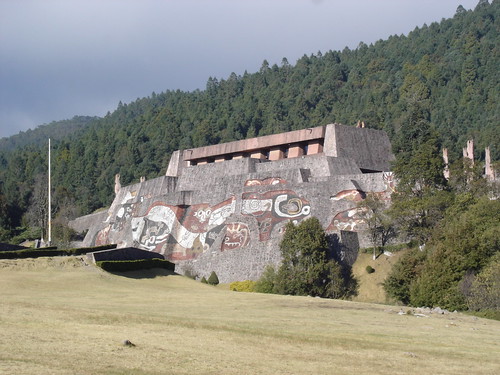
The Otomi Ceremonial Center is an gigantic architectural tribute to one of the oldest indigenous cultures in Mexico: the otomi people. It was built over an extension of more than 85 hectares in 1976 by the Mexico State governor Jorge Jimenez Cantu, in what once was the ancient otomian city of Temoaya. The purpose of the building of the Otomi Ceremonial Center was to: pay tribute to the memory and present of this ancient indigineous culture, in order to preserve the cultural values, the identity of the people and the family cohesion of the otomian ethnic group, located at the northeast of Toluca (Mexico State capital). Additionally, this center is used nowadays as a state-owned high-performance athletic training center, owed to its high altitude: 3200 m.
Once in entered in the OCC, I went inside as far as I was allowed, stopping in fact up to the point where a label stated: No trespassing allowed past this point, just for athletes ! So I had to stop there and start taking photographs :-( From that point it was possible to see the entrance to the athletes villa.
I receded then to a more frontal point, i.e. a point where I could take a photo from the big main building: an enormous pyramid-like building that dominates the view. You can have a look at it in the following photoset. In the front of the stairs that drive to the pyramid there is a big statue of some otomian god.
After finishing my photo session of the Otomi Ceremonial Center, I started my cycling down to Temoaya (Nahuatl for: where all descend). The road is one of steep descent and bad road conditions, with a lot of holes in the pavement, making this ride to Temoaya particularly dangerous. I passed along my descent to Temoaya by towns with funny names like: San Pedro de Arriba, and later: San Pedro de Abajo :-)
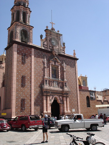
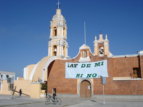
Once in Temoaya, I paid a visit to its beautiful church, main square and local market. After taking some shots, I took the return bus to Mexico City, arriving later at the Toreo terminal with no incidents :-)
Ah, please don't forget to have a look at the above linked GPS track video. I hope you could like it (and its soundtrack) :-)
Thank you for reading. Till the next journey.


