Tecaltzingo + Texmelucan (Puebla), 25.03.07
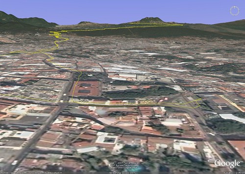
Map Navigation: This dynamic Trackmap shows the GPS track (red line) and some geo-referenced photos (red dots) of the cycling tour. Wheel up and wheel down your mouse to zoom in or zoom out the map. Click on any point in the map to center it on that point. Or just drag the map with your mouse. To see the photos, hoover the mouse over the red dots. Click on the photo to go to the picture page.

Photoset Map
Photoset Show
GPS Track: GPX (MapSource, et al), or KMZ (Google Earth)
GPS Cycling Data:


Distance: 204.25 Km, Total Ascent: 2238 m, Total Descent: 2229, Cycling Time: 8:38 hr, Paused Time: 0:55:27 hr, Avg. Speed: 23.4 Km/hr, Max Speed: 63.4 Km/hr, Energy Expended: 38.47 MJ, Cycling Power: 309.42 W.
Travel Report:
Wow ! At least a ride that starts at a moderately early hour ! I started to ride at 08:30 ! Well before my usual rides :-) As I had plenty of time, I decided to go to a town near Texmelucan (in the eastern state of Puebla), return in bike included :-)
The whole journey comprehend at least 200 Km, since only to arrive at Texmelucan 95 Km are required, along an ascent of at least 1000 m. At the end of the day, my GPS receivers recorded 204 Km and more than 2200 m of total ascent ! No wonder why my knees are aching a little today :-(
In order to arrive at my destination, I took the Zaragoza Av., and continued all the way along the paid highway to Puebla. I had decided to take the free highway, but somehow I missed the cross where I should had deviated to take the free highway to Puebla, instead of the paid one. The bifurcation between both of them is currently a mess, as some kind of traffic bypass is being constructed as we speak. As this cross is a gigantic traffic jam, I lost the junction and had to continue over the paid highway.
But when I arrived at Rio Frio, passing the Llano Grande summit (alt: 3200 m), I branched out of the paid highway, and merge myself with the free one ! This was my first time on this road ! I have cycled a lot of times along the paid one, and now it was time to know this new road to me. I can say that this road (the free one) on the side of Puebla is excellent. Good carpet conditions, and superb scenics. But on the side of Mexico State, it is much less exciting, as the asphalt carpet is abandoned, showing a lot of holes :-(
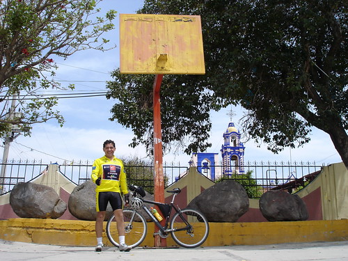
The target of my travel was a town called Tecaltzingo, 5 Km to the southwest of San Martín Texmelucan. San Buenaventura Tecaltzingo (complete name) houses, in its main square, in front of its church, five big stones with carved drawings, i.e. petroglyphs. Petroglyphs are usually associated with pre-historic cultures. They are considered to be a symbolic pre-writing communication system. The oldest petroglyphs are dated 10,000 - 12,000 years back. Being symbolic in nature, petroglyphs usually display some kind of animal figures (humans included).
The petroglyphs located in Tecaltzingo show in fact, antropo- and zoo-morph figures. I believe I could recognize the figures of a deer, a rabbit and a dog. Somehow I missed the human figures. But you can judge yourself in the following photoset. I do not have the exact date these petroglyphs were made, but they do certainly look pretty old to me. They are estimated to belong to the phase Cholula III (500 - 700 CE).
What really saddens my heart is viewing how some of those ancient petroglyphs have been vandalized, since two of them show drawings and labels painted on them :-( A propo, I forgot to mention that the church and atrium of this town are ... pintoresque, at least.
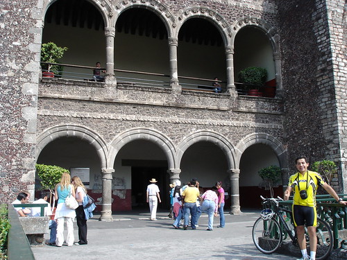
After paying my visit to Tecaltzingo, I returned to Texmelucan (main city in the region). I went to the center of this city, to have a look at its beautiful cathedral. Curiously, this one is of the only cathedral I have seen that allows the parking of autos inside its cathedral atrium ! The facade of this cathedral is really beautiful. It features a lot of lovely barroque reliefs.
The park in the center of Texmelucan houses a Hidalgo statue (Hidalgo is the funding father of Mexico), along a sympathetic kiosk adorned with talavera (blue ceramic).
Once I had finished my cultural excursion, only rested the last half of my trip: the return to Mexico City :-) I took the free highway for my return. I passed, on my way back to the Llano Grande summit: Tlalancaleca, Tlahuapan and Rio Frio. In Rio Frío I made a little stop to eat something (as I was starving) and to take some photos of its curious church.
I don't know why, but the maintenance of the church building in Rio Frio appears to be neglected, as its facade (and associated building) is literally falling in pieces :-( It is really a lovely church, but sadly, abandoned to the elements force ... and with no restoration.
After my visit to Rio Frio, I continued my way to the top of the summit: Llano Grande. When I was arriving there I took some photos of this new vista in front of me: Llano Grande as seen from the free highway. It is curious to see a summit from above, but I reckon that the free highway is a little higher at this point than the paid one.
From Llano Grande I started my descent using again the free highway. Man, this road is dangerous ! Bad asphalt carpet conditions and a lot of U-turns along the road (as the ones seen in the Tour de France). I should have taken photos of this U-turns along my descent in the highway, but my mind was so focused with the terrain and curves, that I forgot to stop and took some pictures. I hope next time, during my climbing up of this road, I could be able to stop and take some photos of those multiple U-turns that I hadn't see before in my previous ridings. I swear that they look just like the U-turns in the climbings of the Tour de France !
At the end of the steep descent (from 3200 m to 2250 m) I entered in Ixtapaluca, a metropolitan town with a lot of people, traffic jams and little organized traffic :-( On my way back home I cycled the avenue that crosses all Ixtapaluca, entering later in the Zaragoza avenue, that took me straight to the center of Mexico City, just aside from our House of Congress. A couple of kilometers later I was safe at home :-)
Thank you for reading. Till the next travel.

Photoset Map
Photoset Show
GPS Track: GPX (MapSource, et al), or KMZ (Google Earth)
GPS Cycling Data:


Distance: 204.25 Km, Total Ascent: 2238 m, Total Descent: 2229, Cycling Time: 8:38 hr, Paused Time: 0:55:27 hr, Avg. Speed: 23.4 Km/hr, Max Speed: 63.4 Km/hr, Energy Expended: 38.47 MJ, Cycling Power: 309.42 W.
Travel Report:
Wow ! At least a ride that starts at a moderately early hour ! I started to ride at 08:30 ! Well before my usual rides :-) As I had plenty of time, I decided to go to a town near Texmelucan (in the eastern state of Puebla), return in bike included :-)
The whole journey comprehend at least 200 Km, since only to arrive at Texmelucan 95 Km are required, along an ascent of at least 1000 m. At the end of the day, my GPS receivers recorded 204 Km and more than 2200 m of total ascent ! No wonder why my knees are aching a little today :-(
In order to arrive at my destination, I took the Zaragoza Av., and continued all the way along the paid highway to Puebla. I had decided to take the free highway, but somehow I missed the cross where I should had deviated to take the free highway to Puebla, instead of the paid one. The bifurcation between both of them is currently a mess, as some kind of traffic bypass is being constructed as we speak. As this cross is a gigantic traffic jam, I lost the junction and had to continue over the paid highway.
But when I arrived at Rio Frio, passing the Llano Grande summit (alt: 3200 m), I branched out of the paid highway, and merge myself with the free one ! This was my first time on this road ! I have cycled a lot of times along the paid one, and now it was time to know this new road to me. I can say that this road (the free one) on the side of Puebla is excellent. Good carpet conditions, and superb scenics. But on the side of Mexico State, it is much less exciting, as the asphalt carpet is abandoned, showing a lot of holes :-(
The target of my travel was a town called Tecaltzingo, 5 Km to the southwest of San Martín Texmelucan. San Buenaventura Tecaltzingo (complete name) houses, in its main square, in front of its church, five big stones with carved drawings, i.e. petroglyphs. Petroglyphs are usually associated with pre-historic cultures. They are considered to be a symbolic pre-writing communication system. The oldest petroglyphs are dated 10,000 - 12,000 years back. Being symbolic in nature, petroglyphs usually display some kind of animal figures (humans included).
The petroglyphs located in Tecaltzingo show in fact, antropo- and zoo-morph figures. I believe I could recognize the figures of a deer, a rabbit and a dog. Somehow I missed the human figures. But you can judge yourself in the following photoset. I do not have the exact date these petroglyphs were made, but they do certainly look pretty old to me. They are estimated to belong to the phase Cholula III (500 - 700 CE).
What really saddens my heart is viewing how some of those ancient petroglyphs have been vandalized, since two of them show drawings and labels painted on them :-( A propo, I forgot to mention that the church and atrium of this town are ... pintoresque, at least.
After paying my visit to Tecaltzingo, I returned to Texmelucan (main city in the region). I went to the center of this city, to have a look at its beautiful cathedral. Curiously, this one is of the only cathedral I have seen that allows the parking of autos inside its cathedral atrium ! The facade of this cathedral is really beautiful. It features a lot of lovely barroque reliefs.
The park in the center of Texmelucan houses a Hidalgo statue (Hidalgo is the funding father of Mexico), along a sympathetic kiosk adorned with talavera (blue ceramic).
Once I had finished my cultural excursion, only rested the last half of my trip: the return to Mexico City :-) I took the free highway for my return. I passed, on my way back to the Llano Grande summit: Tlalancaleca, Tlahuapan and Rio Frio. In Rio Frío I made a little stop to eat something (as I was starving) and to take some photos of its curious church.
I don't know why, but the maintenance of the church building in Rio Frio appears to be neglected, as its facade (and associated building) is literally falling in pieces :-( It is really a lovely church, but sadly, abandoned to the elements force ... and with no restoration.
After my visit to Rio Frio, I continued my way to the top of the summit: Llano Grande. When I was arriving there I took some photos of this new vista in front of me: Llano Grande as seen from the free highway. It is curious to see a summit from above, but I reckon that the free highway is a little higher at this point than the paid one.
From Llano Grande I started my descent using again the free highway. Man, this road is dangerous ! Bad asphalt carpet conditions and a lot of U-turns along the road (as the ones seen in the Tour de France). I should have taken photos of this U-turns along my descent in the highway, but my mind was so focused with the terrain and curves, that I forgot to stop and took some pictures. I hope next time, during my climbing up of this road, I could be able to stop and take some photos of those multiple U-turns that I hadn't see before in my previous ridings. I swear that they look just like the U-turns in the climbings of the Tour de France !
At the end of the steep descent (from 3200 m to 2250 m) I entered in Ixtapaluca, a metropolitan town with a lot of people, traffic jams and little organized traffic :-( On my way back home I cycled the avenue that crosses all Ixtapaluca, entering later in the Zaragoza avenue, that took me straight to the center of Mexico City, just aside from our House of Congress. A couple of kilometers later I was safe at home :-)
Thank you for reading. Till the next travel.


