Cortes Pass (Mexico), 05.03.06

Photoset Map
Photoset Show
GPS Track: GPX (MapSource, et al.) or KMZ (Google Earth)
GPS Cycling Data:


Distance: 180 Km, Ascent: 1617 m, Time: 8:18 hr, Avg Speed: 21.8 Km/hr, Max Speed: 62.4 Km/hr
Travel Report:
This ride was made to reach the imposing Cortes Pass summit, a 3700 meter high pass that stands between the eastern state of Puebla and Mexico State. It was by this pass that spanish conqueror Hernan Cortes and his indigenous allies (mainly tlaxcaltecans) arrived at the Valley of México, coming from Cholula, in order to fight the Aztec empire. This pass is a saddle point located between the two volcanoes that surround Mexico City: the Popocatepetl and the Iztaccihuatl.
Three cyclists decided this time to ride to the Cortes Pass. We started the ride at the Independence Angel monument, in Reforma, Mexico City (alt: 2240 m) at about 07:00. The route we choosed this time was one that passed by a lot of towns (urban and otherwise) along it. Other route we could have taken was the paid highway to Puebla, and just before the toll collect station of Huixtoco, took the Amecameca deviation. But this time we preferred to make a route inside the densely populated south-oriental part of Mexico City. In Mexico this is kind of route is called puebleando (something like: towning).
Some of the towns we passed along our route were: Xochimilco, Tecomitl, Tenango del Aire (alt: 2350 m), Amecameca (2475 m) and Nexapa (2600 m). When we reached Amecameca there was a big street market, which made very difficult our passing by. Then came Nexapa, last town in the route, stopping there some minutes to buy water and food.
From Nexapa starts the gruelling ascent all the way to the saddle point of the Cortes Pass (alt: 3700 m). The road is only ascent. There are no more plains or descents. From Nexapa its a 18 Km long, 1100 m climbing, which gives a grade of 6.11 % over those 18 Km ! Nothing bad ... And the vistas along the road are exceptional, as during an 1100 m ascent, several ecosystems are transversed by. You can have a glimpse of the beautiful road scenics at the following photoset.
There is no much to say about the climbing except that this route is always a torture. There is no easy way to the summit. What else can one do but pedal and pedal ? Having a look at the beautiful vistas always do help a little, but the problem remains, one must continue climbing :-)
After sometime I was finally able to reach the Cortes Pass, where my friends were waiting for me, as they had arrived before to the summit. First thing I did was to eat some quesadillas ! I was starving man. After giving my stomach something, I could continue thinking and start looking the most beautiful places to take some photographs of them.
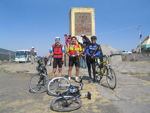
On this site there is a metal plaque that remembers the arrival of the spanish conqueror Hernán Cortés at the Mexico Valley by this very same place, almost five hundred years ago. This plaque shows Hernán Cortés (riding his horse) followed by his army (some also riding a horse, the rest by foot), formed by its spanish companions ... and his indigineous (tlaxcaltecs) allies. Interestingly, the plaque is orientated towards the west, so the image on it renders the Cortés army as if it were coming from Cholula, just as the real deal was
Although in theory the Cortes Pass has a superb view of the two volcanoes: the Popocatepetl and the Iztaccihuatl, that day there were some fires in the forests surrounding the site, so its smoke was blocking the otherwise stunning view of the volcanoes :-(
Just before departing the Cortes Pass and start the descending all the way to Amecameca, a friendly tourist offered us to take some photos of the cyclist group (with the Cortes plaque behind us), offer that we inmediately accepted.
We undertook that vertiginous descent from the Cortes Pass to Amecameca without any incident. Then we rode back by the same route: Tenango del AIre, Tecomitl, and Xochimilco. An hour or so after the mission was happily concluded, arriving safe and sound at the starting point :-)
Thank you for reading. Till the next journey.

1 comment:
wow, ojalá que ahora sí pueda hacerla este verano! la inclinación es bastante parecida a la que se recorre del pueblo de Santiago al punto más alto via carretera en la sierra de monterrey (el vitro parque manzano) así que sé de lo que están hablando!
saludos desde mty!
Post a Comment